


Overview
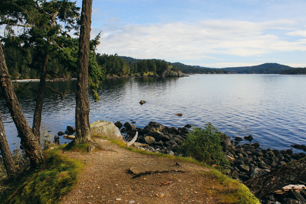
The Coast Trail in East Sooke Park is one of the most scenic hiking trails near the Victoria area as it follows the rocky shoreline along Juan de Fuca Strait. The entire Coast Trail takes about 8 hours to complete one-way, however a portion of the trail in the south of the park, from the aylard Farm area to Beechey Head then returning via forested trails, offers a great hiking experience. The route also passes the petroglyphs at Alldridge Point, carved into the rock by the Coast Salish First Nations.
From the parking lot area, walk down the main gravel trail and at the first trail to your left, go left and follow it. This trail takes you out to the Coast Trail at Campbell Cove and immediately offers scenic shoreline views. Follow the Coast Trail through the forest and to a junction, where going left takes you on a side trip to the view at Creyke Point.
Returning to the junction, continue to follow the Coast Trail as it makes its way through the forest with many glimpses out towards the Juan de Fuca Strait. The trail through this area is not too difficult, although there are some sections where you will have to step up or down and over rocks. Watch your footing through these sections.
The trail reaches the beach area at Becher Bay, where you can easily walk down to the sandy shoreline. Just up from the beach and trail is a grassy clearing with picnic tables and a popular area for families to enjoy the park area during the summer as this picnic area is just a short walk back up a gravel trail to the parking lot.
Continue the hike by following the Coast Trail as it passes a rugged section just up from the beach area. The trail arrives at a sign at the end of the Becher Bay area where it continues into the forest. The next section to Alldridge Point is longer than the last sections and, again, has some areas that might be a bit challenging but overall, the route is not too difficult. It continues to follow the shoreline, through lush west coast forests, passing many arbutus trees in the process.
Eventually, the trail reaches a junction. Go left at the junction and continue a bit further to Alldridge Point, following the signs. Walk out onto the rocks and carefully make your way down, looking for the petroglyphs on the rocks on the right side. The ancient First Nations drawings provide evidence of the Coast Salish people living in the area hundreds of years ago. Unfortunately, the drawings carved into the rocks are fading and can be difficult to see as they have endured years of battering from the winds, rains, and rough west coast weather.
At this point, you have to decide whether you want to continue your hike to Beechey Head or return via an Interior Trail to the Aylard Farm parking lot. The next section of Coast Trail to Beechey Head is much more rugged and difficult, requiring lots of effort to climb up and down over rocks and occasionally needing to use your hands for balance. However, the views are even more spectacular as there are several sections that you hike along exposed rock, offering sweeting views south towards the Juan de Fuca Strait.
If you decide to return to the parking lot, walk back to the junction you passed just before reaching the petroglyphs and go left at that junction, into the forest following the narrow trail to where it reaches a wide trail. Follow the wide trail to a junction that is marked with signage and go right. Continue to follow the route as it emerges from the forest and you return to the Aylard Farm area.
For those hiking to Beechey Head, continue hiking along the Coast Trail as it quickly becomes more difficult. Make your way up and over the rocks, making sure to follow the yellow markers that dot the shoreline showing the path to take. Stop often to soak in the views and watch for wildlife. If you're lucky, seals and sea lions can often be spotted from the trail and, on some occasions, even whales.
After hiking for quite sometime along the rugged shoreline, you reach a sign marking a junction. Go left at the sign and walk a few more meters beyond to where the trail opens up onto a rocky outcrop at the southern most area of East Sooke Regional Park. The views from this point are spectacular on a sunny, clear day as you can see as far south towards Washington State's mountains in Olympic National Park.
Once you have enjoyed the views, return to the sign at the junction you passed and go left, following the trail into the forest, leaving the coastline behind. Within a minute, you reach anther junction. Go right and continue through the forest, making your way up a small hill and over a ridge as the trail goes deeper into the forest. Stay right at the next junction as the trail now becomes a wide path.
The trails through the forest are easy to follow and the junctions are all fairly well marked. Go right again at a junction and continue until you reach a junction where it points to Alldrige Point Petroglyphs on your right. Go straight at this junction (don't go back to the petroglyphs) and continue along the route as you begin to emerge from the forest and can see the parking lot in the distance. Follow the trail all the way to the end where it arrives at the top of the aylard Farm parking lot.
Driving Directions
The Aylard Farm of East Sooke Park is located on the southeast area of the park. From downtown Victoria, drive to Douglas Street and head northbound as you leave the city and continue driving along Highway #1. Take Exit #10 to View Royal / Colwood and stay in the left, exit lane as you pass underneath the highway. Follow Sooke Road for quite some distance as it leaves the malls behind and continues along a single-lane highway towards Sooke. Watch for signs for East Sooke Park and eventually turn left onto Gillespie Road. Follow Gillespie Road until the end and turn left onto East Sooke Road. At the first street on your right, turn right onto Belcher Bay Road and drive to the end, where you will arrive at the Aylard Farm parking area.
Additional Information
Dog-Friendly
Dogs are allowed in East Sooke Park, however must be kept under control at all times. From June 1 - September 15, dogs must be leashed when pass through a beach or picnic area and cannot stay. Please pickup after your dog and me conscious of your pet's impact on the ecology and wild animals in the park.
Toilets
There are pit toilets at the Aylard Farm parking lot in East Sooke Park and also at the picnic area near Becher Bay. There are other pit toilets throughout the park but these are the only options along this route.
Although we try to keep information as current as possible, www.victoriatrails.com makes no warranty or representation as to the availability, quality, fitness for purpose, conditions or accuracy of the information provided with respect to this trail or trails. The information provided herein is further subject to our Terms of Use.
Comments
Add Comment | View All Comments
3.5 out of 5 - 2 reviews