


Overview
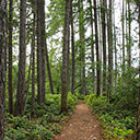
Located along the eastern shores of Saanich Peninsula, Island View Regional Park provides scenic views of Haro Strait while offering an easy walk. The area is a popular location for bird watchers and paleontologists as many fossils from extinct animals have been found in the area. A trail follows the shoreline, up from the beach area and a loop can be completed following a trail that's about 100-meters further inland.
From the parking area, walk along the trail between the beach and the grassy, picnic area as you head northbound. Looking out into Haro Strait, you can see James Island and Sidney Island to the northeast, the small D'arcy Island directly to the east, and the San Juan Islands in the distance to the east on the United States side of the border.
Continue walking along the gravel trail and pass the junction as you take in the scenic views. There are a few junctions with short trails to your left that connect with a trail parallel to the one you are on, however you can choose to loop back on that other trail or just use the one closest to the beach as it has the best views. The trail is easy to follow, even a couple of times where it passes through a sandy section and around some logs, it picks up at the other end and continues.
Eventually, you reach a sandy section with a fence to your left. Continue along until you reach a sign that marks the start of the Tsawout First Nation land. This marks the end of Island View Regional Park.
To return via the other trail, walk back along the sandy section near the fence and continue as it veers to the right from where you came and turns into trail. Follow this trail that has bushes on both sides until you reach one of the three junctions with trails on the left. Go left onto one of the short connector trails and return to the route along the beach. Go right along the trail next to the beach and walk southward as you return to the parking area where you began.
Driving Directions
Island View Beach Regional Park is located just east of Highway #17 in central Saanich. From downtown Victoria, drive northbound on Blanshard Street as it becomes Highway #17 and you leave the city, heading towards the ferry terminal. Drive approximately 16km and turn right at the traffic lights onto Island View Road. Follow Island View Road as it veer right, heading up and wrapping around a small hill before descending and arriving right at the parking area along the beach. You can choose to park here or turn let and follow Homathko Road to another parking area just past the campsite.
Camping Information
The campground at Island View Beach offers scenic views of the beach area looking out into Haro Strait. The Island View Beach Regional Park Campground is open from the Victoria Day long weekend in May until the Labour Day long weekend in September. The campground features 18 RV sites, 24 tent sites, and 5 trailer tent sites.
Amenities include:
- garbage bins
- toilets
- drinking water station
- picnic areas
- group fire ring
Reservations are first-come, first-served. Fees range from about $15 per night tenting, $20 per night RVs, $10 additional vehicle and payable by cash only.
Contact the Capital Regional District for further information.
Additional Information
Dog-Friendly
Dogs are allowed at Island View Beach Regional Park, however they must be leashed and cannot stay in beach or picnic areas from June 1 - September 15. Please keep your dog under control at all times and pick up and remove all excrement from the park.
Toilets
There are toilets located near the parking lot area and also along the trail just north of the parking lot area that’s near the campground.
Although we try to keep information as current as possible, www.victoriatrails.com makes no warranty or representation as to the availability, quality, fitness for purpose, conditions or accuracy of the information provided with respect to this trail or trails. The information provided herein is further subject to our Terms of Use.
Comments
Be the first to submit your experience about this trail.
Add Comment