


Overview
The network of trails through Horth Hill Regional Park provide a scenic escape from the city in a forest rich with native plants. The trails are relatively easy and there is a viewpoint along the Ridge Trail that looks out over the Sidney area.
There are several trails in the park and you can choose your own route. This description largely follows a combination of trails, including the Lookout Loop, Sunset Bridle Trail, and Ridge Trail.
From the parking lot area, walk to the map board and immediately go left, following the the path off to the side along the Lookout Trail. At a junction, go right and continue to follow the Lookout Trail as it passes a second junction, making its way uphill. The trail reaches a set of junctions where there is a map of the park. Go straight and follow the Ridge Trail as it crosses over a raised wooden boardwalk.
Just after crossing the wooden boardwalk, watch for a sign for the Ridge Trail and go right, following it uphill. This section of the route climbs steadily as you quickly gain elevation. After several minutes of uphill, the trail levels and you quickly make your way through the scenic west coast forest.
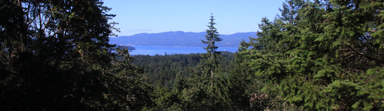
Continue along the Ridge Trail, going straight at two junctions until, just after the second junction, there is a viewpoint on your right. The view looks south over Sidney with some water views of Haro Strait. This is one of the few remaining views in the park as the trees have grown to block other viewpoints in the park.
Return to the trail and continue to follow the Ridge Trail until you reach the end where the trail meets the Sunset Bridle Trail. Go right and down the hill, going left at another junction so that you continue to follow the Sunset Bridle Trail.
Following the Sunset Bridle Trail will return you to the parking lot. After walking along a lengthy stretch, go left at a junction, then another quick right and follow the trail through the park. Within several minutes, you begin to see the parking lot area between the trees as you make your way towards the large map board where you began.
Driving Directions
North Hill Regional Park is located in the northern Sidney area, just off of the highway, not far from the Swartz Bay Ferry Terminal.
From downtown Victoria, drive to Blanchard Street and head northbound following the road as it leaves the city and becomes Highway 17: The Patricia Bay Highway. Follow the highway for quite some distance and pass through the traffic lights at Sidney. Take Exit #31: McDonald Park Road and loop around, crossing over the highway. At a 4-way intersection, turn left onto Wain Road. Drive less than one-kilometre and turn right onto Tatlow Road. Follow Tatlow Road and watch for signs to Horth Hill Regional Park on your right.
Additional Information
Dog-Friendly
Dogs are permitted in Horth Hill Regional Park but please keep your dog on a leash and under control at all times. Please pick up after your dog and remove all poop from the park.
Toilets
There are outhouses located next to the parking lot area but not other toilet facilities within the park.
Although we try to keep information as current as possible, www.victoriatrails.com makes no warranty or representation as to the availability, quality, fitness for purpose, conditions or accuracy of the information provided with respect to this trail or trails. The information provided herein is further subject to our Terms of Use.
Comments
Add Comment | View All Comments
4 out of 5 - 1 reviews